As a follow up to the 2024 herbicide treatment and to inform 2025 management activities, EWM bedmapping was performed in August 2024 by Endangered Resource Services. The following information is summarized from the 2024 Eurasian watermilfoil (Myriophyllum spicatum) Late Summer Bed Mapping Survey reports for Lost Land Lake and Teal Lake by Endangered Resource Services
On August 21, 2024, ERS searched 22.0 miles of transects throughout Lost Land’s visible littoral zone. Five Eurasian watermilfoil beds that covered 7.26 acres (0.57 % of the lake’s surface area) were mapped. This was a 256.13-acre reduction (-97.24%) compared to 2022 when ERS delineated 21 beds covering 263.39 acres (20.84% of the lake’s surface area). Most beds occurred in the far ends of muck bottom bays away from the 2024 treatment areas.
The following are descriptions of the treatment areas from the ERS 2024 Lost Land Lake bed mapping report:
“In 2022, this immense, nearly continuous milfoil bed dominated the majority of the western bay in almost all locations from 4-11ft of water. Posttreatment, it was reduced to a small but dense bed in the Ole Creek Inlet where incoming water flow appeared to have prevented residual herbicide from killing EWM as it did in all other parts of the bed. Test raking both inside and outside the treatment area near the public landing produced no evidence of EWM, and the entire area was now dominated by open beds of native pondweeds (Potamogeton spp.).”
“Despite test raking throughout these former beds, we found no evidence of any surviving EWM.”
“Inexplicably, despite being treated directly, some of the tallest and healthiest remaining EWM occurred along the eastern shoreline of Bed 11. Test raking regularly produced plants that, although severely burned, had survived the treatment and occasionally has as much as a foot of new growth. Despite this, no plants were visible from the surface, and we wouldn’t have known they were there without test raking.”
“EWM was not visible in this area that served as a control for the 2024 treatment. However, several test rakes produced a few severely burned stems with at least some regrowth.”
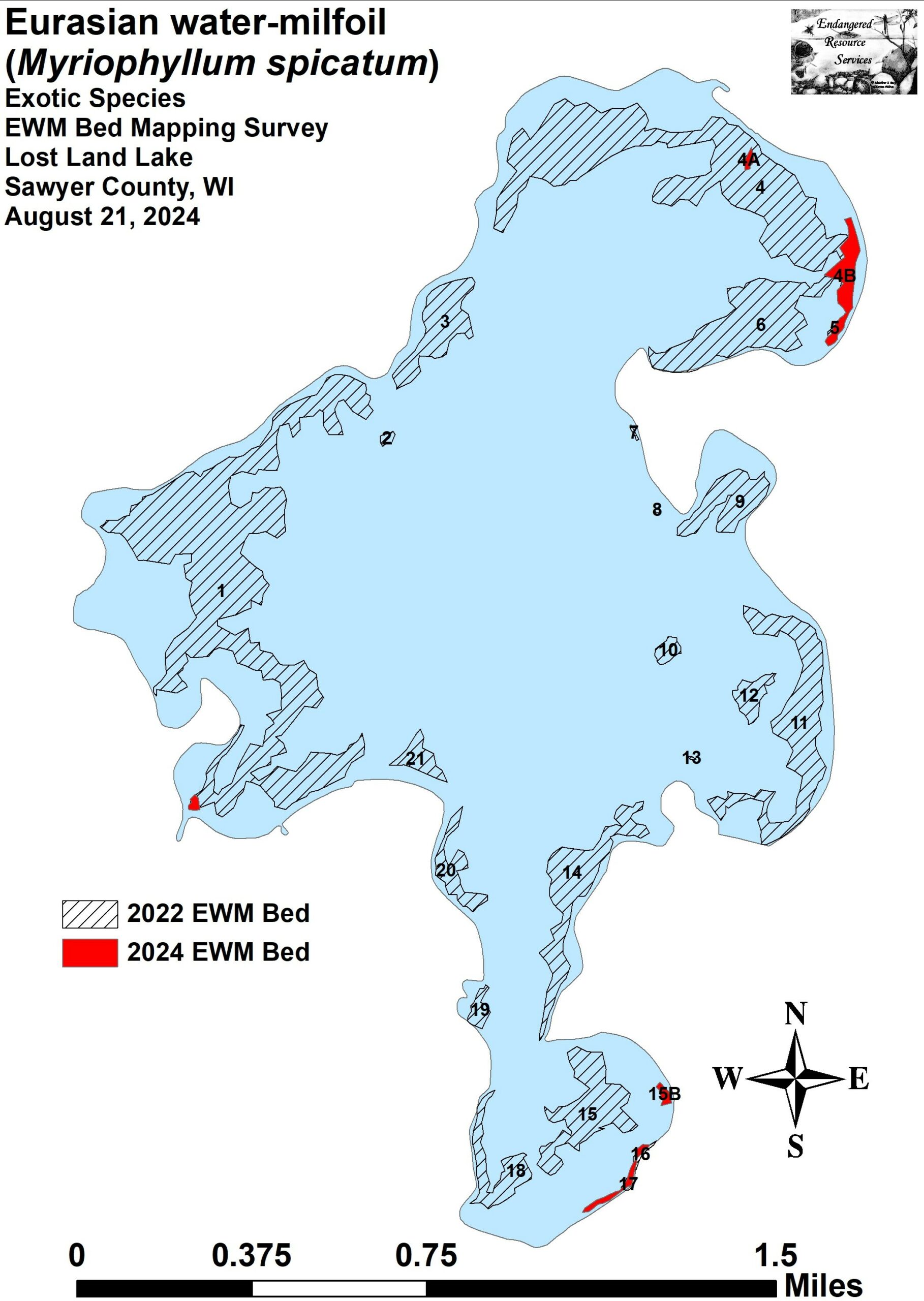
Figure 22. 2024 Lost Land Lake Eurasian Water-milfoil Beds (ERS)
On August 31, 2024, ERS searched 18.6 miles of transects throughout Teal Lake’s visible littoral zone. Eleven Eurasian watermilfoil beds that covered 9.92 acres (0.97 % of the lake’s surface area) were mapped. This was a 34.44-acre reduction (-44.64%) compared to 2022 when ERS delineated 35 beds covering 44.36 acres (4.33% of the lake’s surface area). Most beds occurred along the far east shoreline well away from the 2024 treatment areas. ERS noted that EWM plants showed evidence of chemical burn, and many were laying on the bottom. At the lake outlet, ERS mapped three additional beds that totaled 0.93 acre. Interestingly, these plants showed no evidence of chemical burn, were canopied, likely impacting navigation, and appeared to be growing vigorously.
The following is a description of the Teal Lake treatment area from the ERS 2024 Teal Lake bed mapping report:
“In 2022, these two moderate to high density beds would likely have caused severe impairment had they not been subcanopy, and boats entering Teal Lake from Lost Land Lake had to cut their way through them which left the entire bay full of floating fragments. Following the 2024 treatment, we saw no sign of EWM anywhere in either bed, and test raking both inside and outside the treatment areas also failed to produce any evidence of EWM. We noted the entire treatment area was now dominated by open beds of native pondweeds (Potamogeton spp.).”
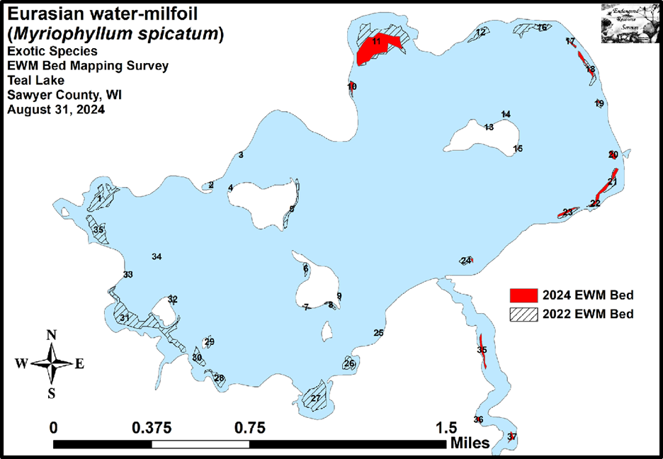
Figure 23. 2024 Eurasian Water-milfoil Beds (ERS)
The QLIA felt that it was prudent to continue mechanical harvesting EWM in the southernmost bay of Lost Land Lake (Steamboat Bay). Harvesting occurred in late summer, and volunteer operators report using the harvester to primarily collect EWM that had uprooted and floated to the surface. However, the Lost Land Lake 2024 bedmapping report indicates that in areas where the harvester was used, EWM was actively reestablishing (Table 11).
“Beds 15B, 16, and 17 – “Bed” 15B consisted of dozens of small newly established plants. Similarly, EWM plants in Beds 16 and 17 were also young. The harvester was running during our survey, and we noticed floating EWM fragments throughout the area it had just passed. We also noted that, in areas that had been recently harvested, EWM was rapidly reestablishing, and it was so confined to these disturbed areas that it looked like it had been planted there.”
This area of the lake is also the farthest from any treatment area, and the lake’s morphology (a narrow neckdown into the bay) along with the north wind at the time of treatment may have limited the travel of the herbicide into this bay.
Clean Boats, Clean Waters (CBCW) is an AIS education/prevention program through which volunteer or paid staff conduct boat and trailer inspections and educate boaters on how to prevent the spread of AIS at boat landings.
In 2024, QLIA volunteers participated in CBCW to assist in educating boaters entering and leaving the Quiet Lakes about AIS and specifically EWM. In 2024, there were 99 boats inspected, 222 people contacted, and 88 volunteer hours. All 2024 data have been entered into the SWIMS database. There are 37 hours remaining for the QLIA to fulfill in 2025 as part of the grant agreement. However, it is recommended the QLIA aim to meet or surpass 2024 CBCW hours in order to continue education efforts and the prevention of spreading AIS and EWM to other nearby lakes that do not have EWM (Spider Chain, Moose Lake, and Ghost Lake primarily).
As an additional education effort, the QLIA aimed to install a ‘Decontamination Station’ at the Lost Land Lake boat landing. This site is owned and managed by the WDNR, and the installation of any new signage requires a land use agreement. As such, an agreement was obtained in September 2024 to install an AIS Removal Station sign. WDNR personnel, Jeanne Sherer, was contacted for the AIS Removal Station template (below). The sign will be installed in 2025 by QLIA volunteers.
It is apparent that the 30-acre ProcellaCOR treatment in Lost Land Lake resulted in nearly a whole-lake treatment of Eurasian watermilfoil in 2024. However, areas with surviving plants could rapidly reestablish in 2025. Herbicide concentration testing indicates that the herbicide was consumed fairly quickly within Lost Land, but low levels still had notable impact across the 1,264-acre waterbody. Despite the apparent success of controlling EWM in 2024, it is important to note that the unintended whole-lake effect of the treatment may have inadvertent consequences. There are many unknowns regarding the potential disruption of biotic processes and impacts to larval fish, zooplankton, native plant species, etc. that are integral to a lake’s ecosystem.
Harvesting may be relieving minor navigation impairment, but it may also be contributing to the spread of EWM based on the abundance of floating fragments released during the harvesting process. Based on observations from ERS, the northeast and south bays of Lost Land Lake are likely to have the highest EWM densities in 2025. Mechanical harvesting should be carefully considered as a management option in areas where EWM reaches nuisance levels and is causing navigational impairment.
While lake-wide relief from EWM is an outcome that is ideal for getting the most out of the money spent on the treatment, this was an unintended result with unknown consequences that should be avoided in the future. Continuous exposure to herbicides can cause EWM to develop resistance to the herbicide, reducing future effectiveness and possibly resulting in more harm to the native plant community. While some plant community indicators show improvement from May to August in the pre and post treatment surveys, these changes could be attributed to the natural shifts in plant communities through the growing season and not solely to the herbicide treatment, so these results should be regarded with caution. Future whole-lake point intercept surveys should be compared to the 2016 and 2022 point intercept surveys for a better understanding of impacts to native species.
Future management actions should take into consideration the risks of harming native plants which would open more areas for EWM growth and reduce the valuable ecosystem services provided by a diverse plant community. It should also be noted that EWM, despite being a nonnative species, also provides ecosystem services such as fish habitat, shoreline protection from waves, carbon sequestration, etc.
Schmidt’s Aquatic representative, Hamilton Harvey, notes that many lakes with a similar outcome as Lost Land Lake can expect 3-5 years of relief from EWM. As such, the QLIA should use this time to continue education and handpulling efforts and utilize smaller, focused herbicide treatments at most. Ultimately, further herbicide treatments are at the discretion of the WDNR, and consideration of these factors will be taken into account.
The 6-acre ProcellaCOR treatment at the entrance of the thoroughfare into Teal Lake also produced residual control of EWM in the entire western half of Teal Lake in 2024. EWM showed evidence of chemical burn and a general reduction in density in the eastern portion of the lake;
however, because so many of those plants survived, those beds could reestablish in 2025. Based on these observations, the north-central bay and along the entire eastern and southeastern shorelines of Teal Lake are likely to have the highest EWM densities in 2025.
Selection of possible treatment areas in Teal Lake should take into consideration the level of navigation impairment and overall density of the EWM beds. Teal Lake has a much steeper bathymetry and generally a more sandy to rocky substrate than Lost Land Lake, making it a less hospitable habitat for EWM to establish. The QLIA should consider increasing handpulling efforts on small, shallow beds and strategically select beds for herbicide treatment based on density, impact on navigation, impacts to the fishery, and other criteria to be determined in conversations with the WDNR.
Eradication of EWM is an unrealistic goal for any waterbody, but especially so in a system where it is as widespread as it is in Lost Land Lake and Teal Lake. Focusing management to reduce navigational impairments and impact to native plants should be the primary focus of the QLIA.